|
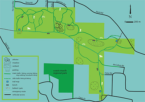
Main Trails: Existing trails which are currently clearly defined, well used and provide main connections to all other trails within the 707CP. These trails will be identified on maps with specific trail names, identified with markers, and be multi-use (pedestrian, cycling, horseback riding).
Side Trails: Existing narrow trails which currently receive infrequent use and provide access through environmentally sensitive areas within the 707C. While still referenced on the 707CP trail map and designated with trail markers, side trails will remain unnamed and will be limited to pedestrian and cyclist use only. Some existing side trails that create trespassing issues will not be signed or maintained.
The RDN will work in consultation with residents of Gabriola Island to develop and implement an accurate and comprehensive trail way-finding system for the 707CP, (including trail names, markers and maps), to improve park accessibility and safety which will be in keeping with the community's desire for unobtrusive and rustic park signage.
|
Park amenities will be installed at key locations throughout the 707CP that both suit and enhance the park's wilderness recreation experience. Only park amenities that enhance the park's recreational function with no negative impact on its ecological and cultural values will be installed along main trails and accesses. The following amenities are allowed inside the 707CP: entrance signage, trail signage or markers, and rustic benches.
Parking areas will be developed inside the 707CP boundary to minimize impact to park neighbours and to provide a safe and accessible staging area for all park users, with minimal disturbance to the park's natural and cultural values.
An emergency access route through the 707CP will be designated and maintained in collaboration with the Gabriola Volunteer Fire Department.
|


